New research from Dartmouth provides the first evidence that the Arctic’s frozen soil is the dominant force shaping Earth’s northernmost rivers. Permafrost, the thick layer of soil that stays frozen for two or more years at a time, is the reason that Arctic rivers are uniformly confined to smaller areas and shallower valleys than rivers to the south, according to a study in the Proceedings of the National Academy of Sciences.
But permafrost also is an increasingly fragile reservoir of vast amounts of carbon. The researchers calculate that as climate change weakens Arctic permafrost and polar waterways churn up the thawing soil, every 1.8 degrees Fahrenheit (or 1 degree Celsius) of global warming could release as much carbon as 35 million cars emit in a year.
“The whole surface of the Earth is in a tug of a war between processes such as hillslopes that smooth the landscape and forces like rivers that carve them up,” says Joanmarie Del Vecchio, who led the study as a Neukom Postdoctoral Fellow with her advisers and study co-authors Marisa Palucis, an assistant professor of earth sciences, and Colin Meyer, a professor in the Thayer School of Engineering.
“We understand the physics on a fundamental level, but when things start freezing and thawing, it’s hard to predict which side is going to win,” Del Vecchio says. “If hillslopes win, they’re going to bury all that carbon trapped in the soil. But if things get warm and suddenly river channels start to win, we’re going to see a large amount of carbon get released into the atmosphere. That will likely create this warming feedback loop that leads to the release of more greenhouse gases from Arctic permafrost.”
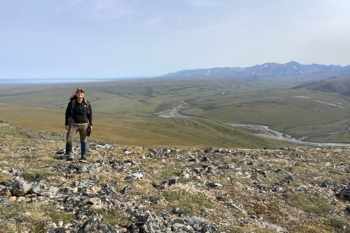
The researchers set out to understand why Arctic watersheds—the total drainage area of a river and its connected waterways—tend to have less river area than watersheds in warmer climates, which can have extensive tributaries that spread over the landscape. Del Vecchio, now a visiting scholar at Dartmouth and an assistant professor at the College of William and Mary, conceived of the study in 2019 while conducting fieldwork in Alaska. She hiked uphill from her riverside worksite and beheld a vista of sheer mountain slopes unbroken by rivers or streams.
“It seemed like the hillslopes were winning and the channels were losing,” Del Vecchio says. “We wanted to test whether it was temperature shaping this landscape. We’re very lucky to have had the amount of surface and digital elevation data that’s been produced in the past few years. We couldn’t have done this study a few years ago.”
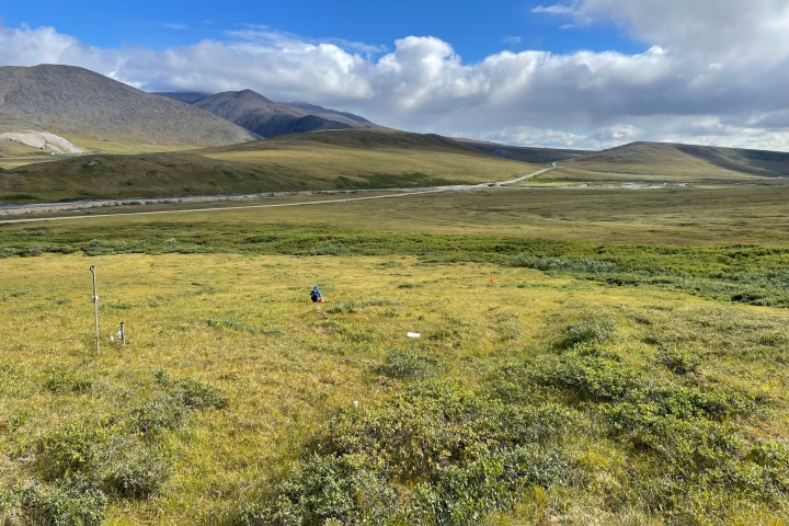
The researchers examined the depth, topography, and soil conditions for more than 69,000 watersheds across the Northern Hemisphere—from just above the Tropic of Cancer to the North Pole—using satellite and climate data. They measured the percentage of land each river’s channel network occupies within its watershed, as well as the steepness of river valleys.
Forty-seven percent of the analyzed watersheds are shaped by permafrost. Compared to temperate watersheds, their river valleys are deeper and steeper and about 20% less of their surrounding landscape is occupied by channels. These similarities are despite any differences in glacial history, background topographic steepness, annual precipitation, and other factors that would otherwise govern the push and pull of water and land, the researchers report. Arctic watersheds are shaped by the one thing they have in common—permafrost.
“Any way we sliced it, regions with larger, more plentiful river channels are warmer with a higher average temperature and less permafrost,” Del Vecchio says. “You need a lot more water to carve valleys in areas with permafrost.”
Permafrost’s power to limit the footprint of Arctic rivers also allows it to store vast amounts of carbon in the frozen earth, according to the study. To estimate the carbon that would be released from these watersheds due to climate change, the researchers combined the amount of carbon stored in permafrost with the soil erosion that would result as the ground thaws and is washed away as Arctic rivers spread.
Research suggests that the Arctic has warmed by more than 3.6 degrees Fahrenheit above pre-industrial levels, or roughly since 1850, Del Vecchio says. Scientists estimate that a gradual thawing of Arctic permafrost could release between 22 billion and 432 billion tons of carbon dioxide by 2100 if current greenhouse gas emissions are reined in—and as much as 550 billion tons if they are not, she says. The International Energy Agency estimates that energy consumption in 2022 spewed more than 36 billion tons of carbon dioxide into the atmosphere, an all-time high.
The Arctic has been adapted to the cold for so long that no one knows how much, nor how fast, carbon will be released if permafrost thaws on an accelerated timescale, Palucis says. “While the Arctic has experienced warming in the past, the scary thing is how rapidly it’s occurring now. The landscape must respond quickly, and that can be traumatic,” she says.
Palucis recalled an Arctic research trip when she saw a chunk of bedrock the size of a small building break off from a cliff. The culprit of the cleaving was a small stream of water that had seeped into the rock and weakened it.
“This is a landscape that is adapted to colder conditions, so when you change it, even a small amount of water flowing through rock is sufficient to cause substantial change,” says Palucis, whose research group uses the Arctic as a stand-in for Mars to study the Red Planet’s surface processes.
“Our understanding of Arctic landscapes is more or less where we were with temperate landscapes 100 years ago,” she says. “This study is an important first step in showing that the models and theories we have for temperate watersheds just can’t be applied to polar regions. It’s a whole new set of doors to go through in terms of understanding these landscapes.”