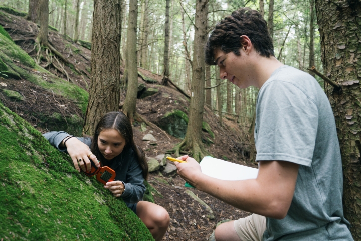
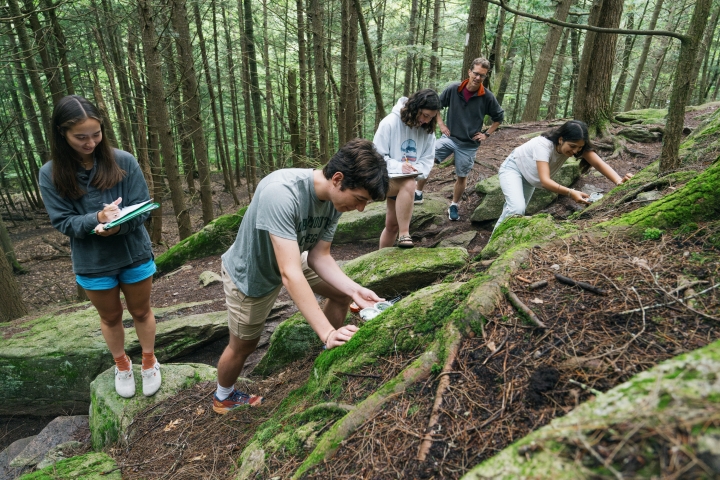
As part of Dartmouth’s decarbonization efforts, earth sciences students taking the Materials of the Earth course this summer have developed a three-dimensional model of the rock formations beneath the Dartmouth campus. Their new understanding of the geology could help drillers predict what kinds of rock they will encounter during the installation of geo-exchange borefields under Chase Field #4 this fall, and future such work elsewhere on campus.
The Chase athletic practice field will be the first area of campus to host a network of deep wells—part of a geo-exchange heating and cooling system that will advance President Sian Leah Beilock’s commitment to address climate change and sustainability by helping Dartmouth move away from using fossil fuels for its energy needs.
In April President Beilock announced that Dartmouth will invest more than $500 million in the next five years to accelerate campus decarbonization efforts and reduce carbon emissions on campus by 60% by 2030 and 100% by 2050.
The success of geo-exchange projects depends on how effectively underground rocks exchange heat, making it crucial to understand the types of rocks present where the wells are drilled. The earth sciences course is focused on understanding the types and locations of rocks in the Earth’s subsurface and how they are oriented.
“This is a great opportunity to lean into the concept of the campus as a laboratory, adapting an existing course to take advantage of the investment we’re putting into decarbonization,” says Carl Renshaw, professor of earth sciences, who is leading the course.
“There aren’t very many places on campus where we can see outcrops of these rocks,” says Renshaw. What’s more, he says, the area has a complicated geologic history. Students used observations taken at the limited number of outcrops and drilling logs from exploratory boreholes drilled last winter to come up with a conceptual model of the structure of the subsurface under campus, including under Chase field.
Their new model of the subsurface includes the identification of a previously unknown fault that cuts across the North End of campus. “When you’re walking down the hill to Dewey parking lot or the hills at the start of Route 10 north to the former golf course you are crossing the fault. The fault has weakened the rocks which were then eroded by Girl Brook to create the Dewey parking lot valley,” says Renshaw.
The students say the course has helped them take information from the classroom and apply it to real questions and situations in the field.
“Being able to use our knowledge of mapping and the geologic history of Hanover in addition to the learning we’d built in the course about structures and 3D visualization was really awesome,” says Shreya Gandhi ’26.
The new fault captured in students’ models could help make a potential future geo-exchange well field in Dewey Lot more efficient, says Renshaw, who will also be co-teaching a pilot service-learning course on climate change and resilience sponsored by the Climate Futures Initiative. “Much like an underground pipe, faults help focused groundwater flow, which can help increase heat exchange in the subsurface. By drilling the wells near the fault, the geo-exchange system will be more effective.”
Gandhi, who plans to major in physics and economics with a minor in earth sciences, was thrilled to be among the first students to study the data from the boreholes.
“When working with others on the maps, we discovered that these questions of structure in the subsurface are actually much more complicated than the simpler examples that we understand within the scope of the classroom,” she says.
Jacob Gordon ’26, an earth sciences major and geography minor, is excited to see what other things research might eventually reveal. “We always hear about how much we know about the Earth and exactly how it is structured from the crust to the core, but projects like this show that a lot of the current information scientists have about just the first few hundred feet, or even sometimes just the surface, is wrong,” he says.
The students’ work based on the borefield data is a step in “a direction in which we understand our Earth better,” says Gordon. “I feel this understanding is especially important in the face of climate change, where many solutions, such as geo-exchange projects, must take advantage of the Earth in creative ways while mitigating damage.”

